BOATING

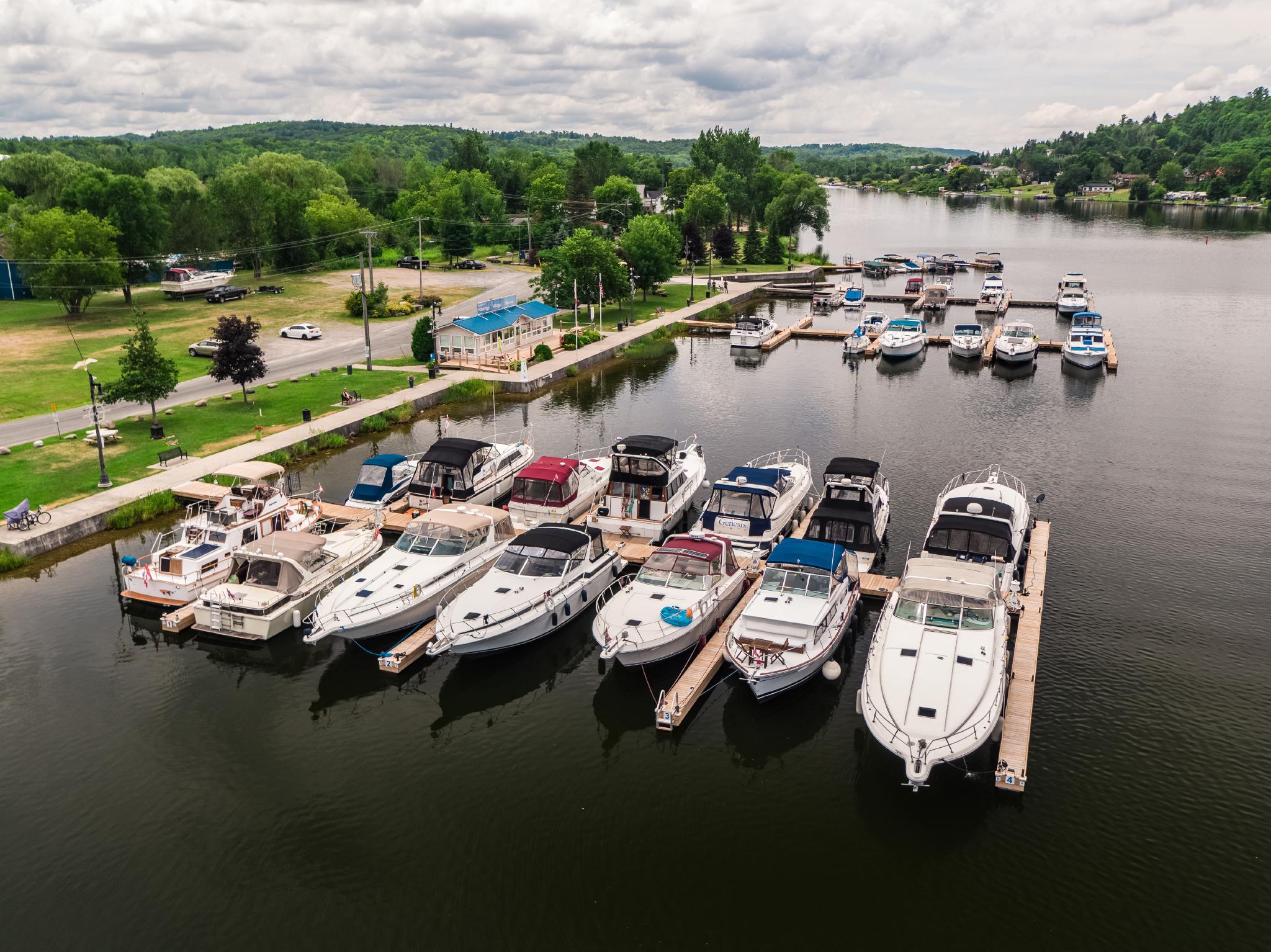
Lakes, rivers, and the iconic Trent-Severn Waterway make Kawarthas Northumberland a boater’s paradise.

Just east of Toronto and just west of Kingston, Kawarthas Northumberland is Ontario’s undiscovered boating paradise. We are home to over 350 lakes & rivers, many of them connected by the historic Trent-Severn Waterway. We also have beautiful waterfront towns on Lake Ontario, like Cobourg and Port Hope, and some of the best multi-species fishing grounds in Ontario.

Looking for more details specifically on fishing? Jump to our dedicated Fishing page.

If you’re seeking advice on non-motorized canoe, kayak, and SUP destinations, visit our Paddling page.

EXPERIENCE THE HISTORIC TRENT-SEVERN WATERWAY

Connecting Georgian Bay to Trenton and Presqu’ile Bay on Lake Ontario, the Trent-Severn Waterway is the backbone of Kawarthas Northumberland. Managed by Parks Canada, the Trent-Severn Waterway is a National Historic Site of Canada. But this historic waterway is far more than just a canal. Less than 60km of its nearly 400km is man-made canals. The rest is natural lakes and rivers framed by limestone gorges and the iconic Canadian Shield. These diverse bodies of water are home to some of the best multi-species fishing in all of Ontario and over a dozen provincial parks as well as several unique conservation areas.

The locks of the Trent-Severn are also at the heart of towns and villages with vibrant cultural scenes, delicious locally-sourced cuisine, and award-winning craft breweries. The storied shores of the Trent-Severn embrace an abundance of trails (including the Kawartha Trans Canada Trail), and some of Ontario’s most scenic driving and cycling routes. Suffice it to say that travellers on and along with Trent-Severn Waterway will be spoiled for choice between on-water escapes and excursions on land.

Haven’t got a boat of your own? No worries—book an excursion with Liftlock Cruises and relax while the Island Princess gives you the grand tour, or stay for longer with a Le Boat houseboat rental.

Looking for info on how to use the Trent-Severn Waterway? See Parks Canada’s official resources on how to navigate the TSW:

VISIT THE CHARMING TSW TRAIL TOWNS

Kawarthas Northumberland invites you to explore the communities of Canada’s first Waterway Trail Town Program located along the Trent-Severn Waterway National Historic Site. Boat, paddle, cycle, hike or drive along this renowned inland passageway through historic lock stations and into quaint communities with unique offerings for every visitor. Visit tswtrailtowns.ca to learn more about each Trail Town, or visit the linked community pages to start your explorations.

TSW Trail Town logo, a green town silhouette with a watery blue strip below

EXTEND YOUR STAY WITH A HOUSEBOAT RENTAL

Take your family or get away with a group of friends for a perfect vacation on the Trent-Severn Waterway, the Houseboat Capital of Ontario. A houseboat vacation gives you all the freedom to choose your own adventure, all at your own pace and leisure. Take all the comforts of home with you on the water, navigating the lock system from lake to lake, stopping for lunch along the way in Bobcaygeon or grilling up your own in the middle of the lake! Swim, paddle, stargaze, and cast your line right from the boat. Make some stops along your route and discover the charming and quaint towns and villages. You can even head to shore to go to the theatre, check out a concert, visit a farmers market, or do some retail therapy at some of the many unique stores and shops.

Read our Unique Places to Stay in Kawarthas Northumberland blog post for more memorable trip ideas.

QUICK AND CONVENIENT WATER ACCESS

If you want to put your boat in the water, in any of our over 350 lakes and rivers, you need to start somewhere—and that somewhere is usually a public boat ramp. Our resident fishing blogger, Chris Huskilson, has provided a list of some of the public ramps and the fish from shore GPS coordinates.

LakePublic Ramp CoordinatesFish from Shore Coordinates
Katchawanooka Lake 44° 25’47.8″N 78° 16‘11.2″W
Little Lake (Peterborough) 44°17’55.5″N 78°18’17.9″W
Little Lake (Peterborough) 44 17’58.5″N 78 18’31.7″W
Little Lake (Peterborough) 44 17’48.6″N 78 18’57.8″W
Little Lake (Peterborough) 44 17’36.0″N 78 19’00.1″W
Mitchell Lake 44° 34.035‘ N 78° 57.391 W
Otonabee River 44° 12‘43.0″N 78° 21‘18.1″W
Otonabee River 44°24’59.5″N 78°15’55.5″W
Otonabee River 44 12’56.0″N 78 14’00.8″W
Otonabee River 44 22’22.4″N 78 17’14.8″W
Otonabee River 44 22’10.5″N 78 17’27.3″W
Otonabee River 44 21’11.1″N 78 17’33.7″W
Stony Lake 44° 32‘01.7″N 78° 08‘40.0″W
Rice Lake44°14’30.0″N 78°09’30.9″W 
Rice Lake44°15’50.5″N 78°03’48.1″W44°15’49.5″N 78°03’47.2″W
Pigeon Lake44°18’01.5″N 78°33’21.1″W44°18’01.5″N 78°33’21.1″W
Pigeon Lake44°35’11.6″N 78°30’41.2″W 
Stoney Lake44°32’01.7″N 78°08’40.0″W 
Stoney Lake44°33’54.2″N 78°08’17.1″W 
Balsam Lake44°34.421’N 78°47.661’W 
Balsam Lake44°34.676’N 78°53.718’W 
Scugog Lake44°9.661’N 78°49.948’W 
Scugog Lake44°6.445’N 78°56.613’W 
Round Lake44°30’18.2″N 77°52’35.5″W 
Crowe Lake44°28’16.6″N 77°46’02.5″W 
Jack’s Lake44°42’39.4″N 78°03’57.3″W 
Chandos Lake44°50’31.9″N 77°59’00.5″W 
Canal Lake44° 33.608‘ N 79° 2.744‘ W 
Otonabee River44° 24‘59.5″N 78° 15‘55.5″W 
Otonabee River44° 22‘03.8″N 78° 17‘26.0″W 
Otonabee River44° 21‘13.9″N 78° 17‘27.9″W 
Otonabee River44° 19‘32.3″N 78° 18‘11.5″W 
Otonabee River44° 16‘48.7″N 78° 18‘59.4″W 
Otonabee River44° 16‘26.6″N 78° 19‘26.1″W 
Otonabee River44° 12‘43.0″N 78° 21‘18.1″W 
Otonabee River44° 11‘04.5″N 78° 20‘09.8″W 
Otonabee River44° 12‘04.3″N 78° 18‘29.0″W 
Otonabee River44° 12‘19.3″N 78° 16‘49.0″W 
Otonabee River44° 12‘55.6″N 78° 13‘59.9″W 
Dalrymple Lake44° 38.416‘ N 79° 6.699‘ W 
Mitchell Lake44° 34.035‘ N 78° 57.391 W 
Katchawanooka Lake44° 25‘38.5″N 78° 16‘16.6″W 
Kasshabog Lake44° 36‘39.2″N 77° 59‘31.9″W 
Mississauga Lake44° 42.534‘N 78° 19.700‘ W 
Salmon Lake44° 49.559‘N 78° 26.831‘ W 
Gull Lake44° 49.240‘N 78° 46.670‘ W 
Little Boshkung Lake45° 0.363‘N 78° 42.227‘ W 
Otonabee River44° 24‘59.5″N 78° 15‘55.5″W 
Little Lake44° 17‘55.5″N 78° 18‘17.9″W 
Sturgeon Lake44.36329 N 78.73700 W44.363557 N 78.737161 W
Burnt River44.782447 N 78.651960 W 
Lovesick Lake44.558 N 78.208 W 
Gull River44.74390 N 78.82477 W 
Bass Lake44.67863 N 78.52511 W 
Cameron Lake44.53726 N 78.74132 W 
Big Cedar44.60154 N 78.16528 W 
Coon Lake44.60289 N 78.19526 W 
Belmont Lake44.4860283 N 77.8176624 W 
Little Boshkung Lake45 2.710′ N 78 43.199′ W

OTHER RESOURCES

Read More

The Kawarthas Northumberland blog is the place to go for longer stories and additional recommendations. Browse the articles below to find out more about boating in the region.

Aerial view of kayakers paddling around a rocky island
Fall Getaways
Kawarthas Northumberland

A Trip Around the Lake with Lovesick Kayaking

After just a short time on the water it’s clear Stony Lake lives up to the name. Pines lean dramatically from rocky islands as we glide past in our kayaks, en route to a high bluff overlooking scenic Burleigh Falls. Alex Grant, owner and lead guide of Lovesick Kayaking, shepherds us into a sheltered bay

Read More »
A hand holds ice cream in front of a lake view
Day Trips
Kawarthas Northumberland

Taste of the TSW with Jeff Bray: Kawartha Dairy

Jeff Bray is the co-founder and festival director of the award-winning Cultivate Festival in Northumberland County. He’s also an instructor at Centennial College, where he teaches about food tourism, a former restauranteur, and a previous contributing writer to Watershed Magazine. We asked Jeff to give us his thoughts on a few of the unique Taste of the

Read More »
Overhead view of cake boxes and a pink plate
Food and Drink
Jeff Bray

Taste of the TSW with Jeff Bray: Cake by the Lake

Bobcaygeon is broken into two parts: the mainland and the islands. Together, they make up an idyllic cottage country community.

The main island is by far the largest. This is where you’ll find the largest concentration of shopping, outdoor recreation rentals, and food and beverage options. Bridges across the Bobcaygeon River connect it to the mainland—and to the second island, home of Lock 32 along the Trent-Severn Waterway.

The third island is the smallest of the three, and only big enough for a handful of buildings. It’s easy to miss, but explore and you’ll find a hidden gem: Cake by the Lake, a specialty bakery that packs a surprising variety into its tiny shopfront.

Read More »