Pigeon Lake: Big (Boyd / Chiminis) Island Canoe Route
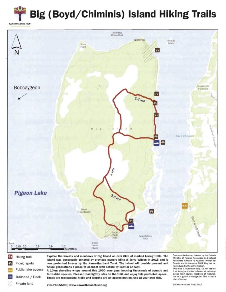
Update 25/03/21: The “shore lunch spot” at the southern end of the island has recently been upgraded with a new dock and signage. It also offers access to 8km of hiking trails in two connected loops, so visitors have the option of a short or long hike.
Route Overview
Difficulty: Easy to Intermediate – potential big water and wind/wave action
Distance: 4km round-trip from launch at end of Bear Creek Road to your picnic location of choice on eastern shore of Boyd/Big Island; 9.5 km for full circumnavigation.
Duration: Day Trip
Portages: None
Shuttle Info: Not required.
Escape to Another World
One of the uncanniest sensations that canoeing creates in the mind of the paddler is the sense of being so close and yet feeling so far away. Something happens when you feel your weight transferred from the land to the water that tells your whole body and mind that you’ve entered a new realm at that in-between or liminal layer that’s neither air, water nor land. The rules are different here.
The song your paddle sings, whether it’s the rhythmic splash of the bow’s forward stroke, or the ripples and eddies of the stern paddle’s underwater return, helps guide the inveterate paddler to a mysterious realization. Even though you’ve left your dwelling and driven a ways to the put in, somehow, on the water, you’ve arrived – you are home.


Meanwhile, as we’re so lucky to be able to experience here in Kawarthas Northumberland, even a minimal investment of time and energy can pay huge dividends in seclusion and natural beauty. Growing up in the suburbs of Toronto, my friends and I had to work hard to find a space where we were surrounded by none of the obvious signs of human interference. We explored the woods between housing developments and dropped into the river valleys leading down to Lake Ontario. It was hard work to find those places, especially for us kids, and once we did, very often it was such a narrow slice of land and waterscape that even a turn of the head would ruin the effect.
Now, traversing the lakes and rivers that flow through the heart of Trent-Severn towns like Buckhorn, Bobcaygeon, and even Peterborough, the dimensional shift of entering the boat, coupled with the song your paddles sing, can transport you to innumerable sites in which to let your mind wander across the ways humans have not yet affected the natural substrate of this land of shining waters.
Big Island
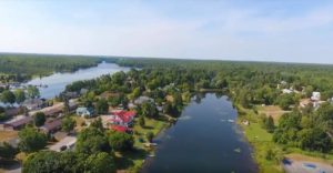
Big Island, also known as Boyd or Chiminis Island, is located in the northern reach of Pigeon Lake. At over 1000 acres, this is the largest undeveloped island in the Kawarthas. Its diverse landscapes include mixed deciduous forest, with a shoreline of white spruce, punctuated by wetlands, and the prairie-like species of an interior limestone alvar. Accordingly, the island supports a rich tapestry of plant and bird biodiversity that can keep naturalists engaged for days.
Its history includes thousands of years of human habitation as a meeting place and harvesting centre, and it remains a culturally significant site for the people of Curve Lake First Nation. Over the last few generations, the island has been a favourite picnic and fishing destination for the local and cottager community, and while much of the interior can still be described as pristine, this use was beginning to take its toll on the shoreline.
In 2015, the Kawartha Land Trust (KLT) received the vast majority of the island by donation, and immediately launched a successful year-long campaign to secure a stewardship endowment that enables them to conserve the property indefinitely.
Big Island is still an ideal four-season location for fishing, and its many coves and inlets serve as natural picnic locations. The Kawartha Land Trust has improved the trails and signage on the island, making it a lovely spot for hiking and even snowshoeing and cross-country skiing when the snow flies. Under the new conservation plan, fire-building and overnight camping have been prohibited, along with any harm to wildlife or vegetation, including hunting, and while motorboats are allowed along its shores, motorized vehicles are not allowed on the island itself.
This doesn’t bother us much, since the best way to explore Big Island is to arrive from the east by canoe, and explore the ribbon of life that connects the shoreline to the shallow coves and offshore islands in this region of Pigeon Lake. There is a convenient launch point on the rocky shore just down the trail from generous public parking at the foot of Bear Creek Road. I’ve easily managed to navigate a canoe trailer around volunteers’ vehicles while transporting canoes for shoreline restoration missions with the Kawartha Land Trust.
The half-kilometer stretch of open water between the shore of Pigeon and the island is known as the Back Channel, and tends to be more sheltered from wind than the open waters on the western side of Big Island. That said, we’ve occasionally had to tack our canoes, especially on return trips from the island, as even the Back Channel can become choppy later in the day when the winds pick up. Regardless of the conditions, we always keep eyes peeled for hunting raptors, and often spy osprey, the increasingly common bald eagle, as well as the ubiquitous turkey vultures on patrol in the Kawarthas.

Closer to shore, we paddle in “hush mode” so as not to spook the great blue herons wading in the shallows and train our owl eyes to spy the flash of blue as indigo buntings alight on the highest white pine perch, or swoop through the dogwood foraging for insects.
There are at least seven landing and picnic spots along the eastern shoreline of Big Island, each of which is highlighted by Kawartha Land Trust signage. We stopped on one with a picnic table and spread out our mid-morning snack of fruit and freshly brewed coffee to wash down some great local fruit and some award-winning butter tarts from Buckhorn’s own Country Mart.

Each of these sites is connected to the network of maintained interior trails, including a central and a southern loop, around four-kms each, joined by a one-kilometer corridor. Sturdy shoes and socks will help you traverse the mixture of forested and limestone terrain, and protect against an unexpected brush with poison ivy.
As a final consideration, one of the most powerful ways to connect with a natural area is to help conserve it. Many paddlers practice this ethos by removing the usual human detritus from their common sites, treading lightly while they do. Under their ongoing conservation efforts on Big Island, the Kawartha Land Trust has created a schedule of ongoing events for shoreline restoration and trail maintenance to help connect visitors to the property in the best way possible, and their team is usually accompanied by ecologists and natural history interpreters to enrich the experience.