Balsam Lake Provincial Park Paddling Routes
Route Overview
Difficulty: Easy – Intermediate (depending on distance)
Distance: launch from beach where rental canoes are stored, paddle to:
– Indian Point Peninsula: 5km return trip
– Grand Island: 10km return trip
– Canal Mouth: 14km+ return trip
Duration: Day Trip
Portages: None
Shuttle Info: Not required / Optional
Rental Equipment:
Canoes available for rent from Balsam Lake Provincial Park
What Makes This Route Special?
Great paddling routes don’t just “happen.” It takes a network of people interested in developing them. There is an amazing network of cyclists in Kawarthas Northumberland, all of them discovering, developing and planning these amazing cycling routes. Likewise, we’ve got some avid paddlers in the region that get out there and find amazing places to paddle. Here’s a story about how that happened! Tired and thirsty after a full days’ paddling on different hidden gem of the Trent-Severn Waterway, our team stopped at the Canoe and Paddle Pub in Lakefield, Ontario, for evening refreshments. The meat and cheese board arrived promptly (including a flight of award-winning local beer) and in a moment of refreshment-induced expansiveness, the table as a whole began to reconstruct Pierre Trudeau’s famous canoeing dictum, from his essay The Ascetic in a Canoe.


While we may have fudged the numbers a bit, and taken issue with the phrasing, at least we all agreed with hierarchy of vehicles, especially since our former Prime Minister esteemed the canoe most highly, claiming that nothing “purifies you more rapidly and inescapably” than a canoeing expedition. (Incidentally, you can see Pierre Trudeau’s canoeing jacket and Bill Mason’s canoe at The Canadian Canoe Museum in Peterborough!) We toasted our fifteen kilometers paddled that day, snapped up another bite of baguette with the finest meats and cheeses, and spread out the maps to plan our next adventure.
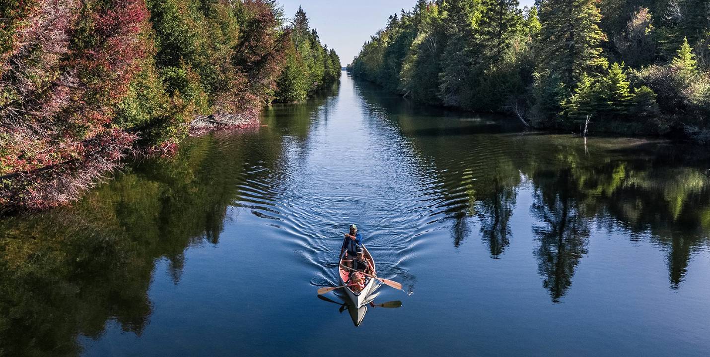
The sight of maps across the table drew in Hugh Dobson, the pub’s co-owner and an inveterate paddler, fresh off his own epic, thousand-plus kilometre paddle from “Lakehead to Lakefield” in celebration of Canada 150. Hugh was curious to hear more about our project. Having just traversed the western corridors of the Trent-Severn Waterway, Hugh quickly realized he was a valuable resource. After listening to our short-list of Trent-Severn Hidden Gems, he brought out his phone, opened up his Instagram feed, and passed the phone towards us. This is the photo he showed us, and he thought its location might stump us. We all sat there, mesmerized by a photo showing a long, narrow stretch of undeveloped cedar shoreline punctuated by towering white pines, and glass-smooth waters. Hugh was right: we had no idea where that was, but the immediate response was unanimous, “We must paddle there.”
https://www.instagram.com/p/BW8RpPXAP8A
Balsam Lake Provincial Park
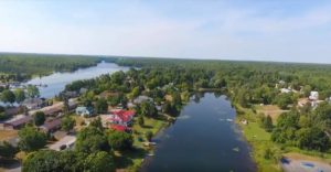
Balsam Lake Provincial Park is ten square kilometers of protected woodland and shoreline on the northwestern shores of its namesake lake. It has the distinction of being located on the highest body of freshwater in Canada from which sea-worthy craft can reach all the major oceans and circumnavigate the globe. (To learn more about exploring other spots on Balsam Lake, check out our blog about Coboconk.) As well as being a natural stopping place for boaters on the Trent-Severn Waterway, Balsam Lake Provincial Park is well known for its sandy beaches, day-trip hiking trails, summer canoe rentals, and for hosting its very own farmer’s market. Renowned for its fishery, Balsam Lake is good for pickerel and muskie as well as small and large mouth bass. There are also waterside cottages for rent, and Balsam Lake Provincial Park staff manage the nearby Queen Elizabeth II Wildlands Park, whose interior lakes, rivers and trails represent some outstanding opportunities for backcountry hiking and canoe camping in the Kawarthas. After checking in at the park office (where we got some much needed hot coffee), we proceeded to park in one of their several beach-side lots, and an easy 50m carry transported all our paddling gear to the beautiful sandy beaches for which Balsam Lake is known. Of course, we had to stop to let the kids explore the massive walleye sign with creative cut outs for your family’s smiling faces, and pay a visit to their waterfront playground, with swings, bridges and climbing structures.
Most folks launch their own paddlecraft from the sandy beach and tour the immediate vicinity of the park’s waterfront. For a longer excursion, you can cross the northwest arm of the lake and pick a fishing spot near the tip of Indian Point peninsula. For island explorers, Grand Island sits in the centre of the lake and a small offshore island on Grand’s southwest coast presents another clear objective.

That Magical Spot
As it turns out, Balsam Lake is also home to that mysterious and beautiful stretch of water whose photo captivated our crew that day in the Canoe & Paddle Pub. It’s a 2.8 km linear canal connecting Balsam and Mitchell Lakes en route to the famous Kirkfield Lift Lock (second highest lift locks in the world!) and all points west on the Trent-Severn Waterway, and on this day we had it all to ourselves. Briagh and our eldest kid set up shop in the bow, while I managed the stern and kept baby happy in the centre compartment. If you’re not game for the minimum fourteen kilometer return trip, there is also a gravel ramp often used to launch fishing boats just north of the mouth of the canal at a bend in Balsam Lake Drive. Paddling a canoe already places you at the intersection of the two worlds of the air and the watery realm below. When you carve a careful path along the shoreline, you add a third dimension to your travel, since you can peek in on the shoreline happenings as well. Since this canal cuts right through the forest, both sides are close at hand, and paddlers can monitor the bird life among the trees and forest floor of both sides of the waterway. We were literally paddling amid the song of warblers and vireos while watching for sunbathing turtles and sneaky stoats.

The Beach & The Food
After our paddle, we crashed on the beach, splashed in the shallows, scrambled on the glacial erratic boulders dotting the shoreline and chilled out in hammocks strung between the trees lining the edge of the woods and the sand. The kids kept rotating between these stations, while I slipped out to boil some water for hot drinks and set out a spread of snacks on one of the picnic tables. Fresh fruit, Empire Cheese and crackers went perfectly with a collection of butter tarts from the Kirkfield Restaurant and the award-winning Quaker Oaks Farm. It all really hit the spot, washed down, of course, with hot coffee. Before we left, we carved our names in the sand in ten-foot-long letters so our friend Justen Soule with serious drone skills (and permission to shoot in the provincial park!) could capture a unique shot to commemorate another lovely day touring the hidden gems exploring our wider neighbourwood. https://www.instagram.com/p/BcdejbyFJGI
For help planning your trip, click here to contact Kawartha Lakes Tourism. ![]()